GOV.UK
Blog History of government
Organisations:
The National Archives, Prime Minister's Office, 10 Downing Street

Mapping for War and Peace - Ordnance Survey’s maps and the First World War
Posted by: Melanie Osborne, Ordnance Survey, Posted on: 13 May 2014 - Categories: First World War
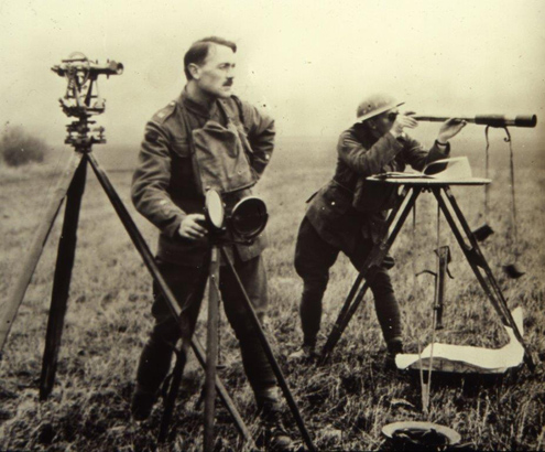
Surveyors on a First World War battlefield. (Image: © Crown copyright)

...in 1918, OBOS printed 300,000 maps. Sixty seven Ordnance Survey staff were killed during the war and they are commemorated at a memorial in a peaceful garden besides the new...

Read more of Mapping for War and Peace - Ordnance Survey’s maps and the First World War - 1 comment

Related content and links

History of government

This blog gives insights into the history of government – its development, its departments and some of the roles and people involved. Find out more.

Categories

Contributors include:

  • The No 10 Guest Historian series
  • The Cabinet Confidential series

Sign up and manage updates

  • Email
  • Atom

Follow us

  • The National Archives on Twitter
  • The National Archives on Facebook
  • FCDO historians on Twitter
  • History & Policy on Twitter

Recent Posts

  • Filling ‘the hole in the centre’: The No.10 Policy Unit – 50 years on 2 May 2024
  • The founding of the NHS: 75 years on 13 July 2023
  • Visiting the secret state: Margaret Thatcher and Intelligence 21 December 2022
  • What the Butler saw: Britain and the Abadan Crisis, 1950-51 7 December 2022
  • Curzon's comeuppance 25 November 2022

Comments and moderation

Read our guidelines

Useful links

  • All GOV.UK blogs
  • All GOV.UK blog posts
  • GOV.UK
  • All departments
  • Accessibility statement
  • Cookies
All content is available under the Open Government Licence v3.0, except where otherwise stated
© Crown copyright